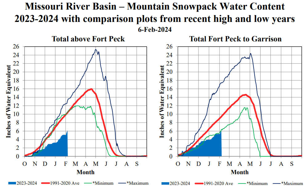

RIVERDALE – Snowfall and its Snow Water Equivalent continues to track well below normal in the Missouri River Basin. The latest numbers revealed in the February outlook compiled by the U.S. Army Corps of Engineers show a decline in the Forecast of Annual Runoff from 20.1-million-acre feet of water in the January outlook to 18.8 MAF. Historically, average annual runoff for the Missouri River System is 25.7 MAF.
While peak snow accumulation throughout the drainage is considered to occur about April 17, the slow start to the accumulation season, combined with long-range weather forecasts, increases the possibility of one of the lowest runoff seasons on record.
The winter snowpack is the prime contributor to spring melt that flows into the river system feeding Lake Sakakawea, and therefore resulting water levels. Lake Sakakawea stood at 1,836.7 feet Thursday, close to its preferred operating level prior to the spring melt. Generally, the spring melt raises Lake Sakakawea considerably, but current projections say otherwise.
An expected summer peak elevation of 1,838.6 feet in the January outlook has been reduced to 1,836.7 in the February outlook, the same as the current water level in Sakakawea. Lake Sakakawea is now projected to drop to 1,833.4 feet by the end of April.
Lake Sakakawea is a multi-use reservoir. It provides electrical power generation, is a source of water for communities, and is the state’s most-visited recreational facility. However, barring further decline in projected water levels, no major problems should result.
The snowpack over the drainage is monitored in two distinct reaches – above Fort Peck in Montana and Fort Peck to Garrison.
Above Fort Peck is primarily Rocky Mountain snowmelt which currently has a measured Snow Water Equivalent of 59% of average. The Fort Peck to Garrison reach, which includes the Yellowstone River, is presently 65% of normal.