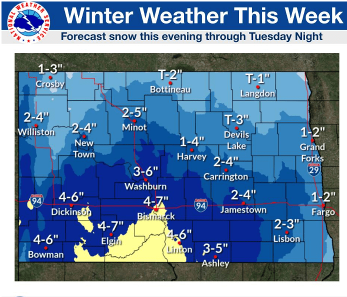

MINOT – The National Weather Service is monitoring weather systems that are expected to bring more snow to the state. Early expectations are that the greatest impact will be south of the Minot region.
According to the NWS, “Snow is expected to develop from southwest North Dakota this evening (Monday) through central and eastern North Dakota on Tuesday. Moderate to heavy snow is possible across southern North Dakota.”
Todd Hamilton, Bismarck NWS meteorologist, explained the reason for the latest forecasts.
“The entire week does look like an active pattern with several systems moving through,” said Hamilton. “The first system is slow moving. Then, Thursday through Saturday is kind of uncertain but could be more impactful across the region. It does look like there’s going to be a Colorado low that moves out into the plains.”
The system can change paths and intensity over the next few days and will be watched closely by the NWS. The first of the two weather systems could dump 4-7 inches of snow in southern portions of the state. Minot is expected to receive 2-5 inches.
The second system, later in the week, initially appears to be tracking into southeast North Dakota and southern Minnesota.
Minot’s snowfall total this winter has been unusually light, at least by historical standards, with just 28.5 inches of snow falling since last October 1. The long-term norm is 38.3 inches.
The state’s capitol city, Bismarck, has borne the brunt of several snowstorms, including 6.7 inches this past weekend. The winter total for Bismarck is 82.1 inches, ranking 7th all-time in the history of the city. Normal winter snowfall in Bismarck, if there is such a thing in North Dakota, is 38.1 inches.
Even with the first official day of spring coming up on March 20, don’t look for a big change in the weather. Long-range outlooks still call for a cooler and wetter spring season.
“Winter is darn near over with spring on March 20, but meteorologically we can’t say that,” remarked Hamilton.
For the latest weather information go to: