fbpx
Published March 1, 2024

Winter Weather Advisory

Written by
The Dakotan
| The Dakotan

National Weather Service

Winter Weather Advisory
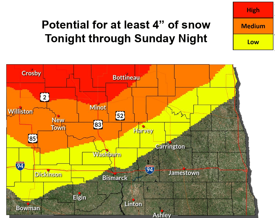
URGENT - WINTER WEATHER MESSAGE

National Weather Service Bismarck ND
130 PM CST Sat Mar 2 2024

NDZ009>011-017>019-021-030330-
/O.CON.KBIS.WW.Y.0007.240303T0000Z-240304T1200Z/
Williams-Mountrail-Ward-McKenzie-Dunn-Mercer-McLean-
Including the cities of Parshall, Watford City, Killdeer,
Stanley, Beulah, Hazen, New Town, Halliday, Underwood, Wilton,
Washburn, Minot, Garrison, Turtle Lake, and Williston
130 PM CST Sat Mar 2 2024 /1230 PM MST Sat Mar 2 2024/

…WINTER WEATHER ADVISORY REMAINS IN EFFECT FROM 6 PM CST /5 PM
MST/ THIS EVENING TO 6 AM CST /5 AM MST/ MONDAY…

  • WHAT…Mixed precipitation expected. Total snow accumulations up
    to 4 inches and ice accumulations around one tenth of an inch.
    Winds gusting as high as 45 mph.
  • WHERE…The Highway 2 Corridor and adjacent counties including
    Williams, Mountrail, Ward, McKenzie, Dunn, Mercer, and McLean
    counties.
  • WHEN…From 6 PM CST /5 PM MST/ this evening to 6 AM CST /5 AM
    MST/ Monday.
  • IMPACTS…Plan on slippery road conditions. Areas of blowing snow
    could significantly reduce visibility.

PRECAUTIONARY/PREPAREDNESS ACTIONS…

Slow down and use caution while traveling. The latest road
conditions can be obtained by calling 5 1 1.

BRIEFING LINK: https://www.weather.gov/media/bis/DssPacket.pdf

Stay connected to the latest news
Subscription Form (#3)

About the Author

Trending Now
The Dakotan Newsletter
Subscribe to get the latest news delivered straight to your inbox
Newsletter Form (#4)
© AndMuse, LLC 2024 Login Email
LIVE: 2022 Minot Mayoral Forum
Click to Watch Live
cross
linkedin facebook pinterest youtube rss twitter instagram facebook-blank rss-blank linkedin-blank pinterest youtube twitter instagram